Ⅰ. Introduction
The northern waters of the West Sea coexist with the constant military tension between the NLL, which is the "de facto" maritime boundary under the Armistice Agreement system, and the complexity of the management system due to the overlapping of the exclusive economic zone (EEZ) between South Korea and China. Baengnyeong Island is a front-line island close to Jangsangot in Hwanghae Province, North Korea, and is a key base for defense and surveillance in the West Sea, and is the first area to be damaged in the event of a conflict between South Korea and North Korea, as shown by the 2010 shooting of the Cheonan and the shelling of Yeonpyeong Island (Chun, 2011).
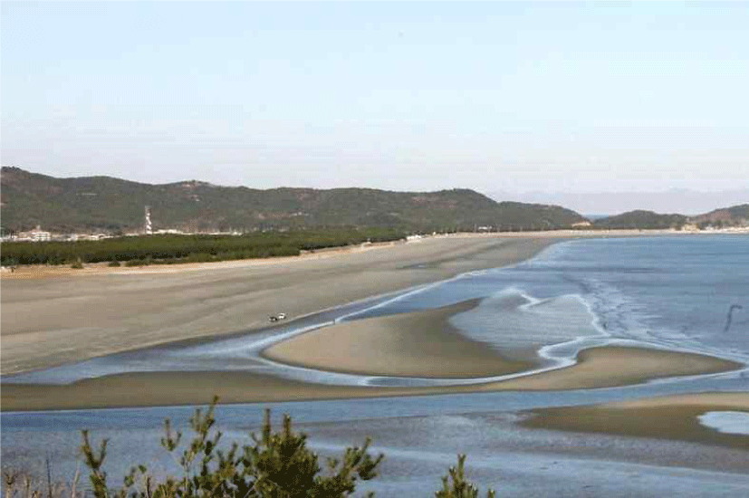
Despite the fact that it is a disputed region, the South Korean government is still working to develop a Baengnyeong Airport on the Island. Until the 1970s, air traffic on Baengnyeong Island was carried out by transport aircraft because Sagot Beach, located on the eastern coast of the island, was strong enough to function as a natural runway.
However, after the reclamation and freshwater lake projects weakened the ground of Sagot Beach, transport planes stopped taking off and landing, and external transportation only relies on ships(Fig. 1).
To solve this problem, the Ministry of Land, Infrastructure and Transport and the Ministry of National Defense first proposed to the Ministry of Land, Infrastructure and Transport in August 2014 to lift the no-fly zone and develop a small airport with a runway control tower and a passenger terminal.
In December 2022, as the Special Act on the Five West Sea Islands was revised and the airport construction project passed a preliminary feasibility study (Oh, 2022). It was promoted in earnest. The Ministry of Strategy and Finance's analysis that construction is easier and costs much less than Ulleung Airport because there is no need to reclaim the sea also had a positive effect on the project. Accordingly, this study attempted to analyze the military and security importance of the development of Baengnyeong Airport in the future hegemonic competition between South Korea and North Korea or between the United States and China.
Ⅱ. Geological and Legal Backgrounds
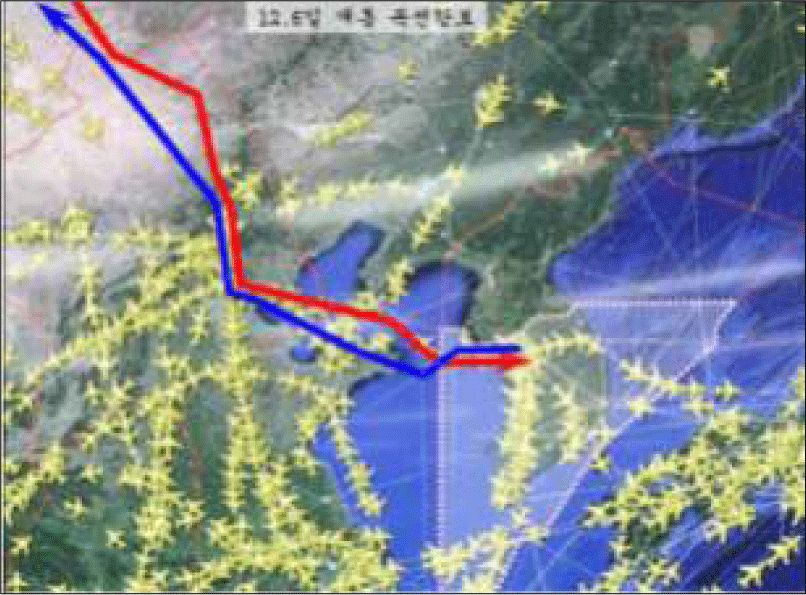
The Northern Limit Line (NLL) is a military control line established by the United Nations Command in 1953, and North Korea unilaterally declared the 'Sea Military Demarcation Line' in the West Sea in 1999(Fig. 2). North Korea has continuously raised objections through the abolition of provisions related to the NLL in 2009(Yoo and Kim, 2021).
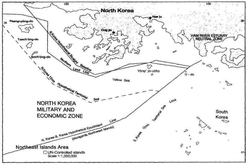
Nevertheless, the NLL effectively controls North Korea's provocations in the West Sea, and has performed the function of a 'de facto boundary line' as a repetitive practice of the NLL(Ha, et al., 2013).
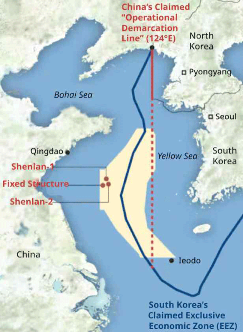
It has been interpreted that the provisional measure area, the Professional Measures Zone (PMZ), was established in the process of implementing the Korea-China Fisheries Agreement from 2000 to 2001, and is jointly managed only for 'fishing', but non-business activities such as the installation of fixed structures are not allowed. As China installed illegal structures in the PMZ between 2024 and 2025, the crisis over the PMZ between Korea and China is escalating. The Korean government and many experts have raised the view that the Chinese government's installation of large aquaculture and fixed structures contradicts the purpose of the agreement (Chosun Daily, 2025.04)1).
Contrary to South Korea's interpretation that China's installation of fixed structures or large fish farm platforms in the PMZ from large fish farm platforms in the PMZ from 2024 conflicts with the "fishing restriction" clause in the existing bilateral agreement, China is increasing the installation of fixed structures while sticking to the position that there is room for interpretation(Fig. 3).
As confirmed in the South China Sea, this has the potential to show a similar trajectory to China's main foreign policy strategy, 'progressive fait accompli → assertion of management and supervision power → infrastructure of civilian convergence'. If this trend is stuck in the northern West Sea, pressure on the freedom of monitoring, access, and navigation in the waters around the Island, including Baengnyeong Airport, could continue to increase(Kim, 2021).
According to the U.S. Department of Defense's annual Chinese military report and the U.S. Office of Naval Intelligence (ONI)’s evaluation, China's unilateral installation of large structures without consultation with the Republic of Korea within the provisional measure area pointed out the deployment of the Chinese Navy's "near sea priority" and the qualitative improvement of submarine and sea strike capabilities. If the continuation of the U.S. deployment in the Yellow Sea is restricted, the Island and Baengnyeong Airport will be able to play the role of intelligence, surveillance, reconnaissance (ISR) and command control as forward bases for military alliances between South Korea and the United States. The development of Baengnyeong Airport may be an indispensable option to fulfill this role(Paul and Andreas, 2023).
The Cheonan(2010.3.26.) or PCC-722 sinking incident occurred near Baengnyeong Island, and the investigation by a multinational joint investigation team, including South Korea and the United States, concluded that "underwater explosion caused by torpedo detonation" was the cause and notified to the international community. Since then, the Northwestern Island Defense Command, which is in charge of defending the five islands in the West Sea, has been established in 2011, strengthening the deterrence and response posture of the Northern Front in the West Sea. Until recently, the Marine Corps' live shooting and increasing training has been regularized, increasing its ability to respond to the initial phase.
In addition, Baengnyeongdo Island has a geographical advantage in the operation of North Korea's West Sea Fleet, monitoring the possibility of penetration into submersibles and semi-submersibles, and detecting coastal artillery and radioactive artillery activities. Detection studies linked to earthquake and sound observation networks have been accumulated in Baengnyeongdo Island, and it plays various roles militarily as a "sensor base" for forward monitoring and continuous monitoring in the concept of island defense of the Navy, Air Force, and Marine Corps(Kim, 2022).
Ⅲ. Needs to Develop a Small Airport
It has been regarded a very urgent task to improve access to air transportation for residents and soldiers living on Baengnyeong Island. If Baengnyeong Airport is built, it will be possible to respond quickly in the event of an emergency in Baengnyeong Island, and the local tourism industry will be expanded to contribute to revitalizing the local economy.
For example, it currently takes about four to five hours to travel from Incheon Port to the Island by ship, and it is known that maritime transport connections are canceled for nearly 80 to 90 days per year due to instability in maritime weather conditions (about 18% of ships' cancellation rate).
In the case of civil aircraft, the average flight cancellation rate is about 16 percent for airports designed for VFR(Visual Flight Rule) flights, but in the case of the airport development project at the island, ILS facilities such as VOR and DME are already included in the project cost, and TACAN, a military mobile navigation safety facility, will be also installed when operating as a civil-military airport, so in this case, it is expected to fall below the average flight cancellation rate of domestic flights of civil airlines based on the flight cancellation rate of instrument landing facilities.
In the waters near the five islands in the West Sea, the waters of South Korea, North Korea and China overlap, and controversy over their status under international law has been steadily arising. In addition, as the number of Chinese naval warships as well as Chinese fishing boats has recently increased, it is urgent to protect the maritime sovereignty of the Republic of Korea. (Increasing the number of operations such as illegal fishing of Chinese fishing boats in the West Sea and Chinese aircraft carriers, etc.)
In the case of China, the IEODO (Ieodo), where the Korea Maritime Science Station is installed, also does not recognize Korea's status recognized by the IMO at all. China arbitrarily sets its air defense identification zone (CADIZ) on Ieodo to overlap with the flight information zone of the Republic of Korea, and for this reason, China monitors the waters around Ieodo Island through its own coast guard or military aircraft.
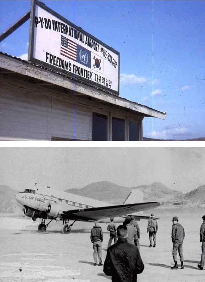
Historically, the coast of Sagot on Baengnyeong Island has been used as a natural runway. During the Korean War, the U.S. military secured the coast of Sagot for airfield use and operated air force aircraft as a strategic point. The U.S. Air Force named the runway on the coast of Sagot on Baengnyeong Island P-Y-DO International Airport and used it as a strategic point during the Korean War. It is known that it played a big role during the Korean War as a strategic fortress such as a natural aircraft carrier that does not sink rather than a natural runway(Fig. 4).
In order to develop Baengnyeong Airport, consultations were held between the Ministry of Land, Infrastructure and Transport and the Ministry of National Defense on the operation of MOAs (military training zones) such as civil aircraft flying in the no-fly zones (P-518, P-116), NLL cross-border prevention measures, navigation safety facilities installation measures, and flight restricted zones (R-131 and R-132). Baengnyeong Airport is a combined civilian-military airport, and the main purpose is to use Baengnyeong Airport for search and rescue or search missions for military aircraft accidents that may occur in the West Sea, rather than the deployment of combat troops from the Air Force or Marine Corps.
The Ministry of National Defense has always been very passive in cooperating with the opening of civilian air routes in consideration of the military confrontation between the South Korea and North Korea and the tension of the ceasefire, and there has been a long-term concession of military training airspace (MOA) after discussions with the Ministry of National Defense, Joint Chiefs of Staff, the U.S. Air Force, and the Ministry of Land, Infrastructure and Transport.
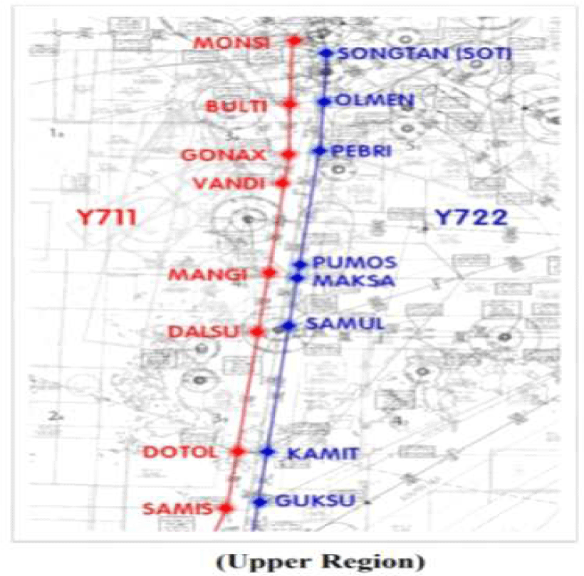
For example, the G597-Y644 route, which is an opportunity to depart and enter China from Incheon International Airport, located 160 to 170 kilometers south of Baengnyeong Island, will be double-tracked, starting with the Korea-China Air Traffic Control Cooperation Conference in July 2012, and the skyway did not open until December 2018. In other words, it took around six years to double track the G597-Y644 air route(Fig. 5, 6).
In addition, discussions between the Ministry of Land, Infrastructure, and Transport and the Ministry of National Defense began in April 2010 when it came to double-tracking air routes (B576, Y711, Y722) linking Gimpo International Airport to Jeju International Airport. However, it took more than two years for the Air Force to reach an agreement with the Ministry of Land, Infrastructure and Transport to coordinate its airspace.
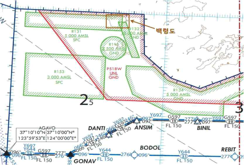
As shown in the above case, the fact that the Ministry of National Defense, which has been passive in adjusting airspace, actively discussed the relaxation of no-fly zones and fly-restriction zones for the development of Baengnyeong Airport proves that the Ministry of National Defense also desperately feels the need for Baengnyeong Airport because it needs a search and rescue mission in the event of an emergency situation for military aircraft in the NLL airspace. This is because in order to develop Baengnyeong Airport and adjust the airspace above the NLL where Baengnyeong Island is located, an airspace committee involving the Ministry of National Defense, Joint Chiefs of Staff, and major U.S. military commanders must be held and approved(Fig. 7).
As a result of the preliminary feasibility review service conducted by the Ministry of Land, Infrastructure and Transport in 2017, Baengnyeong Airport was reviewed in connection with the previously performed small airport service aircraft at Ulleung-do Airport and Heuksan-do Airport. As a result, the 50-seat ATR-42 aircraft was set as the design standard aircraft like the two island airports, and the required length of the takeoff runway was reviewed accordingly.
As a result, RWY 10-28, which is closer to the northeast-southwest direction, was proposed by minimizing the risk of crossings boarder lilne than the north-south direction with the length of the 1,200×30m runway and the direction of the runway at the end of the Solgae district.
In addition, this project is to build a new airport with a 1,200-meter runway, and it is a project subject to environmental impact assessment because it corresponds to the construction of a runway with a length of 500m or more among the construction projects of the airport under Article 22 of the Environmental Impact Assessment Act. Therefore, the Ministry of Land, Infrastructure and Transport, which is the project operator, should conduct a "strategic environmental impact assessment" when establishing a basic plan for the development of an airport or airfield under Article 4 of the Airport Facilities Act(Fig. 8).
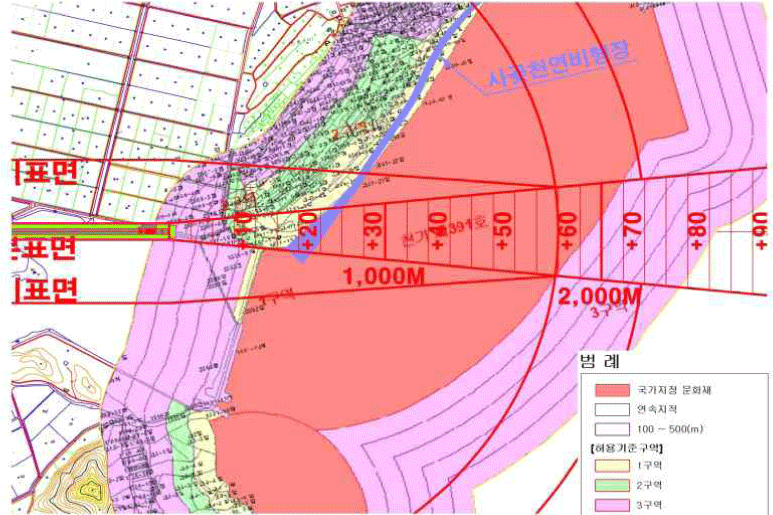
Located adjacent to the Solgae district is the natural airfield on the coast of Sagot, designated as Natural Monument No. 391. If Baengnyeong Airport is scheduled to be built in the Solgae district, an take-off/climb surfaces are set up over the coast of Sagot and will be used as the final approach for aircrafts. It is understood that there would be no environmental hazard at all because it does not directly damage the Sagot beach.
Above and around Baengnyeong Island, most of the airspace above sea level is established and operated as a special used airspace. Special used airspace includes a no-fly zone (P), a flight restriction zone (R), and a warning airspace (military training and military operation zone).
Baengnyeong Island is located within a no-fly zone called P518-W, and in principle, aircraft are prohibited from flying around Baengnyeong Island. The no-fly zone in Korean airspace is mainly set up near the Blue House or near a nuclear power plant.
The use of airspace around Baengnyeong Island is restricted from the surface or the ground to a specific altitude, of which R-131, R-132, R-116, and R-153 are all set as military surface-to-surface shooting ranges. In other words, the flight-restricted zone around Baengnyeong Island is an airspace designated by the Ministry of National Defense, Navy, and Air Force for the purpose of shooting or training.
Fortunately, if Baengnyeong Airport begins operations, the instrument flight route, which was used to depart and arrive at Incheon International Airport and Chinese airports, can be used as it is. The total flight distance is known to be around 140 NM (about 260 km). If an aircraft flies from Gimpo International Airport or Incheon International Airport to Baengnyeong Airport, a flight route has already been set up to allow entry to Baengnyeong Airport from the ANSIM Fix point of the Y697 Chinese port of departure.
Ⅳ. Conclusion
Various military and security risks are inherent in the waters and airspace around Baengnyeong Island. The smost possible scenarios are as follows.
First of all, it is the possibility of local provocations from North Korea that may appear as Baengnyeong Airport is developed. Local provocations can occur in various ways, such as shelling, drones, or submersible vehicles. If North Korea shells or drones or submersible vehicles penetrate near the NLL, the roles of Baengnyeong Island are as follows. It is possible to suppress the landing of North Korean troops on islands and control supply routes(Kim and Lee, 2023).
Additionally, as an ISR base for the ROK-US coalition force, Baengnyeong Airport can protect civilian and military facilities in Baengnyeong Island by detecting and tracking the origin of North Korea. By developing Baengnyeong Airport, Baengnyeong Island can serve as the final outpost to suppress and manage local provocations by the North Korean military and to suppress escalation to the Korean Peninsula.
Secondly, If China continues to install additional large fixed structures on the PMZ or Yellow Sea, Baengnyeong Island could become a base for collecting and monitoring information on the Chinese government's "civilian" assets. Baengnyeong Island and Baengnyeong Airport will be able to play a key role of regular visual, electronic, sound monitoring of China's civilian assets, joint response control of the navy and coast guard, and blocking the "sea bridgehead" when switching to war.
To this end, Baengnyeong-do should strengthen the 'sensor-shooter' solidarity of deterrence and defense posture. It is required to upgrade the ISR architecture of islands, connect multiple sensors (radar, electronic, sound, E/IR, and SAR) to an underwater fixed sensor network (passive array), and quickly switch to an 'early identification -tracking-targeting' system based on data fusion. It is necessary to strengthen the role of Baengnyeong-do's strategic deterrence defense by incorporating the use of earthquake and sound networks accumulated after the Cheonan accident into the regular operation system.
Finally, demonstrating the interoperability of the U.S.-South Korea military alliance in Baengnyeong Island, it is necessary to improve the reliability of deterring disputes between South Korea and North Korea, and between the U.S. and China. It is necessary to strengthen the real-time data exchange with the U.S. military's ISR and target network and the operation of a "hot line" to prevent contingencies. It is necessary to set up a military "detection-identification-determination" time reduction goal centered on Baengnyeong Airport, which responds to the improvement of the quality of China's military power, which is pointed out by reports released by the U.S. intelligence and defense ministries.
With the development of Baengnyeong Airport, Baengnyeong Island will be a central hub for the South Korean military's "sensors, maneuvers, and thermal power" on the west coast of the Korean Peninsula, and will be a strategic "hinge" point to absorb and buffer the ripple of the hegemony competition between the United States and China while curbing North Korea's local provocations.
The proliferation of gray area tactics in China's PMZ will be an opportunity for the Republic of Korea to put structural pressure on access, monitoring, and law enforcement to the West Sea, centering on Baengnyeong Island (Lee, 2025). This would result in improving the deterring reliability of the ROK-US military alliance. Therefore, by utilizing Baengnyeong Airport, (1) upgrading the island-based ISR functions, (2) re-establishing the legal interpretation and practices of the PMZ, (3) strengthening the interoperability of the alliance and enhancing the visibility of the deployment of the Yellow Sea, and (4) enhancing the resilience of civil and military forces.